
Mapping the Moon
Celebrating the 50-year anniversary of landing on the moon
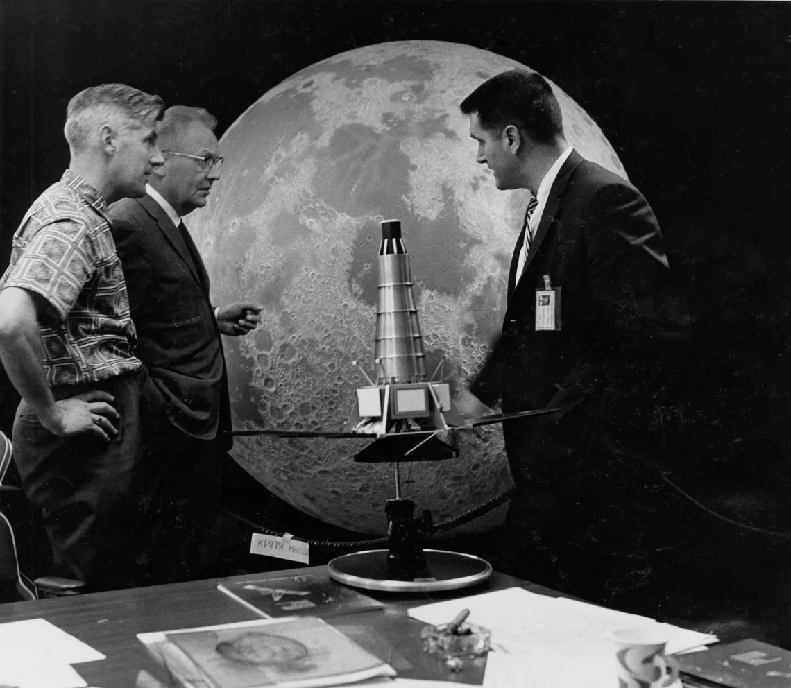
From left, Ewen Whitaker, Gerard Kuiper and NASA engineer Ray Heacock in front of a lunar hemisphere and a model of a Ranger spacecraft.
In 1961, when President John F. Kennedy announced that the United States would land a man on the moon by the end of the decade, lunar and planetary science was still in its infancy.
Its birthplace? The University of Arizona.
The story of the Apollo 11 moon landing — which occurred 50 years ago, on July 20, 1969 — wouldn’t be complete without mention of the endeavors of a team led by Gerard Kuiper, founder of the UA’s Lunar and Planetary Laboratory.
Lunar atlases
Before the space race began with the launch of Soviet satellite Sputnik in 1957, Holland-born Kuiper was the director of the University of Chicago’s Yerkes Observatory in southern Wisconsin, working on compiling the best images of the moon to create a photographic lunar atlas. Until that time, maps of the moon had been drawn by hand, and the names of the moon’s features were not agreed-upon.
At an international astronomical conference in 1955, Kuiper had asked anyone interested in helping him create a moon atlas to reach out. Ewen Whitaker, then the director of the lunar section of the British Astronomical Association, was the only one to respond. Kuiper asked Whitaker to join him at Yerkes Observatory.
Whitaker left for the U.S. the day after Sputnik took to the skies. With funding from the U.S. Air Force, he and Kuiper completed the lunar atlas, then the most comprehensive photographic record of a planetary body ever published.
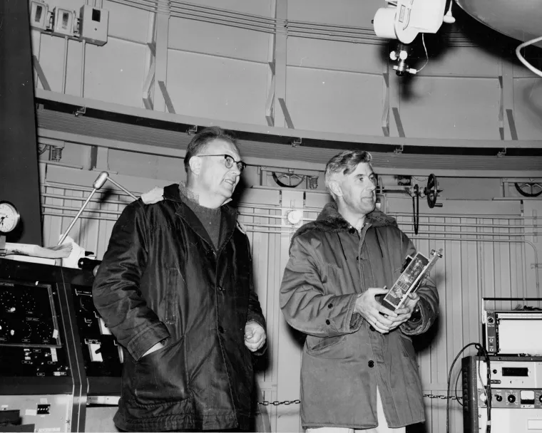
Left: Gerard Kuiper (left) with Ewen Whitaker in the dome of the UA’s 61-inch reflecting telescope on Mount Bigelow 1966. Right: William Hartmann projecting photographic plates of the moon onto a white hemisphere to create the Rectified Lunar Atlas.
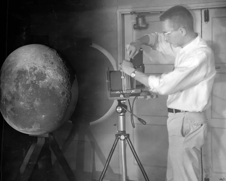
Left: Gerard Kuiper (left) with Ewen Whitaker in the dome of the UA’s 61-inch reflecting telescope on Mount Bigelow 1966. Right: William Hartmann projecting photographic plates of the moon onto a white hemisphere to create the Rectified Lunar Atlas.
Kuiper moves to the desert
But the moist air and cloudy skies of southern Wisconsin were not ideal for observing the moon. Kuiper was drawn to Tucson for the dry, clear night skies, the newly built Kitt Peak National Observatory 50 miles southwest of the city and the surrounding Santa Catalina Mountains, which were well-suited for observatories because of their high elevation.
Kuiper’s mind was set. He and his team moved to Tucson and the UA.
The LPL started out in a corner of the UA Physics, Mathematics and Meteorology Building (now the Physics and Atmospheric Sciences Building). Years later, after considerable growth in the program, NASA funded the construction of what is now called the Kuiper Space Sciences Building.
Kuiper and his team arrived in 1960, the same year their first and second lunar atlases were published. But their work was just beginning.
“Going to the moon became a national priority in the spring of 1961. Until that point, no one else was looking at the moon,” says Timothy Swindle, director of the LPL. Suddenly, Kuiper and his team, with their in-depth knowledge of lunar geography, were in high demand.
Mapping the moon
If astronauts were going to land on the moon, they would need maps. Kuiper set out to create a Rectified Lunar Atlas, which was published in 1963.
To accomplish this, William Hartmann, one of Kuiper’s graduate students, projected the best images of the moon onto a white hemisphere, then took pictures of the globe from the side. This technique allowed him to see what the moon’s surface would look like from above, at every angle, without the distortion experienced when viewing the moon from Earth.
Hartmann, one of the founders of the Planetary Science Institute in Tucson, is an acclaimed science artist and writer. His technique led not only to new theories about the moon’s history but also to the creation of mineral and navigational maps of our celestial companion.
In 1967, Kuiper and his team published another version of his lunar atlas, called the Consolidated Lunar Atlas, which included high-quality prints of all of the best images available of the moon. This version was distributed to support the Apollo missions.
Navigating the moon
NASA wasn’t sure what the Apollo 11 astronauts would find when they got to the moon. Some scientists feared that dust might be so thick on the moon that the astronauts would sink deep into it. Years before the mission, Kuiper participated in a series of robotic missions to the moon to take up-close photos of the surface.
Kuiper saw the importance of looking at the moon as a place rather than just an object in a telescope, Swindle says. He had his graduate students study geology and explore terrestrial landscapes shaped by volcanoes and molten rock, such as the Sierra Pinacate in northwestern Mexico, to better understand the moon’s ancient volcanic landscape.
When the first robotic spacecraft, Surveyor 1, landed on the lunar surface in 1966, scientists announced its landing site. But Whitaker, who had followed Kuiper to Arizona and the LPL, determined a more accurate location by examining the horizon and other geographic features. Because of his success in locating the Surveyor 1 landing spot, Whitaker was asked to locate Surveyor 3 when it landed.
When Apollo 12 reached the moon two years later, Swindle says, “NASA wanted to demonstrate a precision landing. But the problem is, how do you do a precision landing site when you don’t know where anything is? This is before GPS or anything like that.” The location of Surveyor 3, accurately established by Whitaker, became the Apollo 12 mission’s lunar lighthouse, guiding the crew to its pinpoint landing.
While the Apollo program is over, the samples returned from those missions are still being studied. And as efforts to revisit the moon (and possibly Mars) increase, the LPL is already thinking about the needs of future explorers.
On the horizon
Kuiper was director of the LPL until his death in 1973. The Kuiper Belt — the region of the solar system beyond Neptune that contains small, icy bodies — was named in his honor.
To this day, the LPL is a world leader in lunar and planetary science. Currently, the UA is leading the OSIRIS-REx mission to the asteroid Bennu to learn more about the origins of life and the solar system.


